Slovakia · Population

On this page you can find past, current and future population statistics for Slovakia (from 1950-2100), population map, demographics, live population counter etc. . Question: What is the population of Slovakia? Answer: Current population of Slovakia is: 5 459 197*[1], area 48845 km², population density 111.77 p/km². Capital of Slovakia is Bratislava. Continent: Europe.

↓ Population for cities ↓   → Administrative units →

Slovakia · Population 1950-2100

Slovakia · historical and predicted populations (both sexes) for the period 1950-2100 (millions) De facto population in Slovakia as of 1 July of the year indicated. Source United Nations Population Division [1].

What was the Slovakia population at your birthday?*

Enter your birth date to find out. [1]

year:***
month:
day:

Current Slovakia population

5 459 197

Today This year
Population growth Today
xx
Changes every 10007.089 sec.
Population growth This year
xx
Births Today
xx
Changes every 536.254 sec.
Births This year
xx
Deaths Today
xx
Changes every 566.617 sec.
Deaths This year
xx

Sources: [1]
Today's statistic since midnight 00:00.
This year, statistic changes since 1st January
Population = Births** - Deaths

Slovakia population map

City density [2]population density [3]Legend (Click on marker to hide it)
• Population Growth rate: 9 / day = 0.36 / hour = 0.006 / minute = 0.0001 / seconds
• Births Growth rate**: 161 / day = 6.75 / hour = 0.116 / minute = 0.0018 / seconds
• Deaths Growth rate: 152 / day = 6.35 / hour = 0.106 / minute = 0.0018 / seconds.

Current Slovakia population by age and sex for 2025-12-10*

  Male % Female
0-4 124 534 ⇐+5.2% 118 413
5-9 165 209 ⇐+4.9% 157 427
10-14 142 106 ⇐+4.6% 135 912
15-19 92 032 ⇐+4.4% 88 144
20-24 108 870 ⇐+5.9% 102 843
25-29 165 677 ⇐+4.5% 158 528
30-34 189 260 ⇐+3.4% 183 072
35-39 244 355 ⇐+3.7% 235 724
40-44 286 921 ⇐+2.6% 279 640
45-49 206 374 ⇐+0.5% 205 371
50-54 141 511 +3.2%⇒ 146 021
55-59 160 718 +6.3%⇒ 170 914
60-64 197 044 +12.6%⇒ 221 774
65-69 187 531 +18.4%⇒ 222 127
70-74 107 753 +36.3%⇒ 146 854
75-79 60 654 +60%⇒ 97 065
80-84 31 499 +91.3%⇒ 60 257
85-89 22 364 +110.5%⇒ 47 072
90-94 8 983 +176.9%⇒ 24 874
95-99 2 066 +455%⇒ 11 467
100+ 89 +66.3%⇒ 148

Sources: [1]

Ads

age of mother

Childrens per woman

Life expectancy at birth

Population for cities or regions in Slovakia (41)

Bánovce nad Bebravou Trencin Region
Banská Bystrica Banská Bystrica Region
Bardejov Prešov Region
Bratislava Bratislava Region
Brezno Banská Bystrica Region
Čadca Žilina Region
Dolný Kubín Žilina Region
Dubnica nad Váhom Trencin Region
Dunajská Streda Trnava Region
Hlohovec Trnava Region
Humenné Prešov Region
Komárno Nitra region
Košice Kosice region
Levice Nitra region
Liptovský Mikuláš Žilina Region
Lučenec Banská Bystrica Region
Martin Žilina Region
Michalovce Kosice region
Nitra Nitra region
Nové Mesto nad Váhom Trencin Region
Nové Zámky Nitra region
Partizánske Trencin Region
Pezinok Bratislava Region
Piešťany Trnava Region
Poprad Prešov Region
Považská Bystrica Trencin Region
Prešov Prešov Region
Prievidza Trencin Region
Rimavská Sobota Banská Bystrica Region
Rožňava Kosice region
Ružomberok Žilina Region
Senica Trnava Region
Snina Prešov Region
Spišská Nová Ves Kosice region
Trebišov Kosice region
Trenčín Trencin Region
Trnava Trnava Region
Vranov nad Topľou Prešov Region
Žiar nad Hronom Banská Bystrica Region
Žilina Žilina Region
Zvolen Banská Bystrica Region

Sources, Notices

* Value is calculated with linear interpolation from 2 nearest estimated (date->population) data (unofficial).
** Net migration is included in Births with this calculation: Births = Population[1] + Deaths[1].
*** For years before 1950 we dont have population data. Value is approximate calculation using function: 1900 population = 70% of 1950 population.
[1] United Nations, Department of Economic and Social Affairs, Population Division (2015). World Population Prospects: The 2015 Revision. Data are estimates and projections according to a medium-fertility variant. Reused with the permission of the United Nations. Downloaded: 2015-11-15 (un.org)
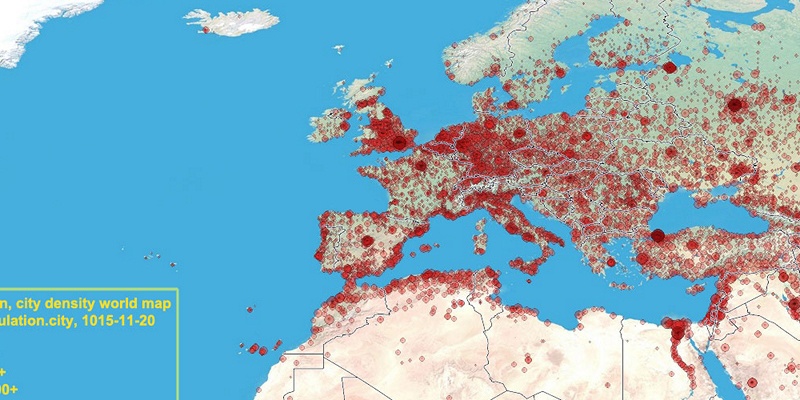
[2] City density map, generated by population.city using data provided to us by 1km.net website. Every circle is city with population over 5000. Link
[3] 
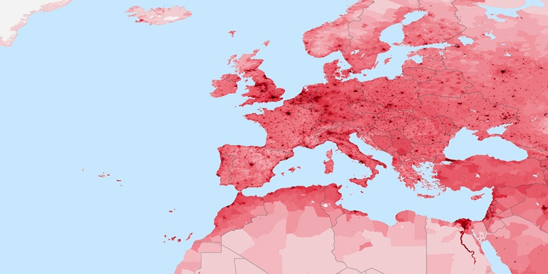
Population density map generated by instructions from daysleeperrr on reddig. Link1. Used data source is the Gridded Population of the World (GPW), v3 online at the the Socioeconomic Data and Applications Center (SEDAC) at Columbia University. Link2. Additional urban land cover: Extracted from Global Land Cover Characteristics Data Base Version 2.0 and Binary MOD12Q1 data on shadedrelief.com. Link3 (PNG,0.5Mb).